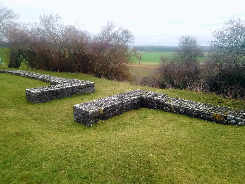
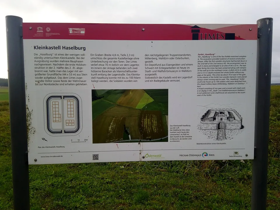
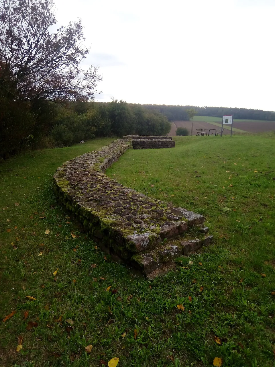


Kleinkastell Haselburg is the site of a small Roman fort on the Limes, the frontier of the empire, in open farmland between the villages of Reinhardsachsen and Gerolzahn near Walldürn. What you see is mostly modern: the low walls of its east gate, partly reconstructed in 1980 after the excavation, and a stretch of its circuit wall, with a board that explains the rest.
What is original and what is rebuilt
Almost nothing of the Roman fort stands. Its stone wall is said to have been pulled down for the church of Reinhardsachsen, finished in shell in 1726, and then for road building, and the plough did the rest: an excavator in 1880 still found four courses of the outer face on the east side, in 1892 only one or two remained, and in 1975 there was no standing masonry left at all (de.wikipedia).
After the 1975 dig the plot with the east gate was bought, and in 1980 the gate was partly reconstructed and conserved by raising its walls a little (de.wikipedia). That is what is on show: the walls of the gate and a low run of wall curving round a rounded corner, which the site board describes as the east gate facing the frontier and the wall up to the north-east corner. No published description says which of the stones in them, if any, are Roman. The timber forts that came before the stone one, the barracks inside and the ditch round the whole fort are known from excavation; nothing in the sources describes any of them as shown on the ground.
The board’s aerial photograph shows the line of the frontier itself as a dark stripe in the crops of the field in front of the fort, about 70 m east of the gate (the site board; de.wikipedia gives the same 70 m).
Is it worth the trip?
Not on its own. This is a few low walls in a meadow and a board, a stop of a quarter of an hour, and almost all of it is modern masonry. It earns its place on a day spent following the Limes: the frontier ran in a near-straight line past here, the fort sat right behind it, and the board makes the layout easy to read. Walldürn, the nearest town, also has a fort bath and a 2.2 km Limes path with conserved watchtower foundations and a rebuilt stretch of palisade (Deutsche Limes-Straße); its own fort is the Castra of Walldürn, about 7 km to the south-east as the crow flies.
Getting there
The fort lies between Reinhardsachsen and Gerolzahn, two villages belonging to Walldürn in the Neckar-Odenwald district (de.wikipedia), about 6 km in a straight line from Walldürn itself. A car park is mapped about 60 m from the remains, with the information boards beside them (OpenStreetMap). No bus stop or station is mapped nearby, so it needs a car, a bike or a walk along the frontier.
It is open ground with no gate or staff, and no admission charge is published anywhere; OpenStreetMap tags it as open at all times. A replica of a small Roman altar found near the fort was set up in 2018 at the former town hall of Reinhardsachsen, Haselburgstraße 8 (Regierungspräsidium Stuttgart).
Visiting details
- Opening hours
- Open ground in a meadow beside the road, with no gate and no staff; OpenStreetMap tags it as open at all times. No operator publishes hours.
- Tickets
- No admission charge is published or tagged in OpenStreetMap, and there is no ticket office.
- Parking
- A car park is mapped about 60 m from the fort (OpenStreetMap node/529644731), with the information boards beside the remains.
Before you go
- No bus stop or railway station is mapped near the fort; it needs a car or a walk or ride along the Limes.
- The Walldürn town museum, which shows the fort's hoard of iron tools and the sword, is listed by the Deutsche Limes-Straße as closed for renovation.
History
The fort stood on a gentle rise roughly halfway between the forts of Miltenberg-Ost and Walldürn, on the stretch of the Upper German frontier known as the Vorderer Limes. Older research dated this line to about AD 155; tree-ring dates from other forts on the frontier support a building programme shortly after the death of Antoninus Pius in 161, though the question is not settled (de.wikipedia).
The first fort was built of timber and earth, about 41 × 37 m (0.15 hectares), with a palisade with rounded corners and two long timber barracks either side of the street joining its east and west gates. It burned down after a short life and was rebuilt larger, about 52.5 × 43.5 m (0.22 hectares), with an earth rampart, timber towers over both gates and a ditch 4.8 m wide and 2.3 m deep all round. Towards the end of the 2nd century the timber face of the rampart was replaced by a stone wall 1.2 m thick, of red and grey sandstone, and the gates were rebuilt in stone; the main east gate was now 3.75 m wide (de.wikipedia). The garrison was probably a detachment from the fort at Miltenberg or Walldürn (the site board adds Osterburken): about 60 to 80 men by de.wikipedia’s reckoning, up to 100 by the board’s.
In the last years of the frontier women also sheltered behind the walls, and the ditch, no longer kept clear, was used for rubbish. The youngest layer of the ditch held a coin of the emperor Gallienus minted in 259 at the earliest; the latest coins from this whole line of the frontier have been found only here and at the fortlet of Rötelsee. To the excavator, Hans Ulrich Nuber, the fort seems to have been among those given up in an orderly way when Rome withdrew from the land behind the frontier in 259/260 (de.wikipedia).
The fort was dug in 1880 and in 1892, the second time for the Reichs-Limeskommission, and completely re-excavated over 1,800 m² by Nuber in 1975. With the fortlet at Rötelsee it is the only one of its kind on this stretch to have been excavated by modern methods, and it showed that small forts could go through several building phases, as most of the larger ones did (de.wikipedia). The finds include a hoard of about twenty bronze and iron objects that had been kept in a wooden box, among them weapons, tools, farm implements, kitchen gear, keys and a shortened sword with an inlaid figure of Victory on its blade (de.wikipedia). The site board says the hoard is shown in the town museum in Walldürn, whose Roman section the Deutsche Limes-Straße lists as closed for renovation.
A small altar found near the fort in the 19th century was lost track of, then turned up again in 2016 on the front of the town hall of Reinhardsachsen. It was taken down to protect the weathering sandstone, a replica was set up in its place in 2018, and the original was to go on show in a museum. Geophysical surveys in 2016/17 found a passage through the frontier close to the fort, leading towards the Germanic settlements on the Tauber, and further research showed that the altar had stood near it (Regierungspräsidium Stuttgart). Since 2005 the fort has been part of the Upper German-Raetian Limes World Heritage Site (de.wikipedia).
Nearby
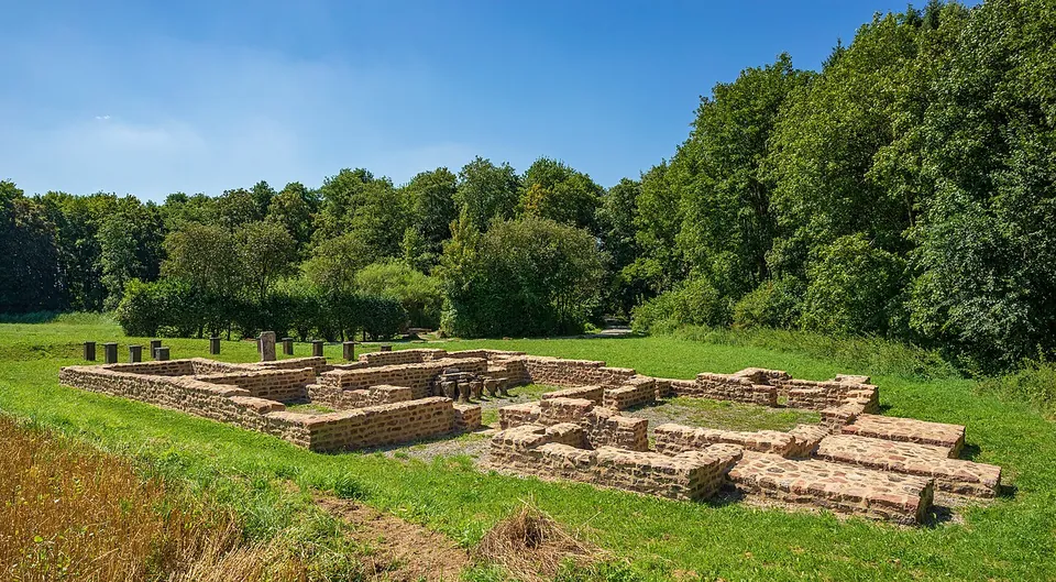
Photo: Roman Eisele · CC BY-SA 4.0 · Commons
7 km · fort · Baden-Württemberg
Castra of Walldürn
Be clear about this before you go: the fort itself has gone.
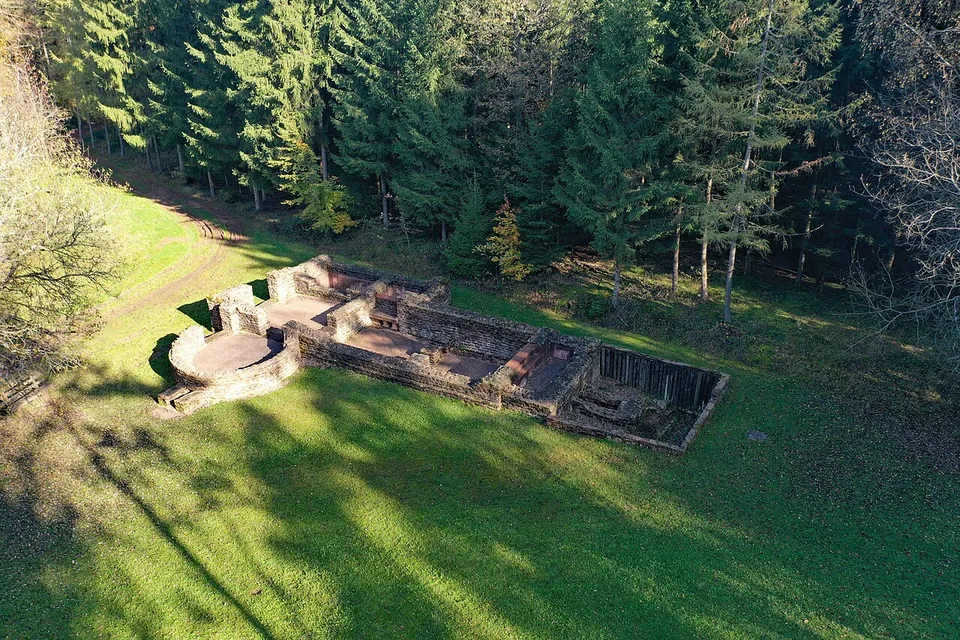
Photo: PaulT (Gunther Tschuch) · CC BY-SA 4.0 · Commons
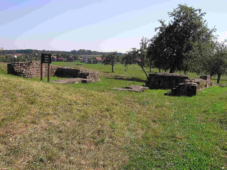
Photo: Schwing · Public domain · Commons
19 km · fort · Baden-Württemberg
Castra of Oberscheidental
The one built thing to look at is the south gate, the porta principalis dextra.


Straight-line distances.
Sources
Every fact on this page comes from the records below, each used under the licence noted.
| Source | Licence |
|---|---|
| Wikidata Q1746865 | CC0 |
| Vici.org 4480 | CC BY-SA (text), CC0 (metadata) |
| OpenStreetMap node/1523513277 | ODbL |
| Wikipedia (de) — Kleinkastell Haselburg | CC BY-SA 4.0 |
| Regierungspräsidium Stuttgart — unveiling of the replica of the Roman altar from Kastell Haselburg (2018) | licence not recorded |
| Deutsche Limes-Straße — Walldürn | licence not recorded |