

What is there today
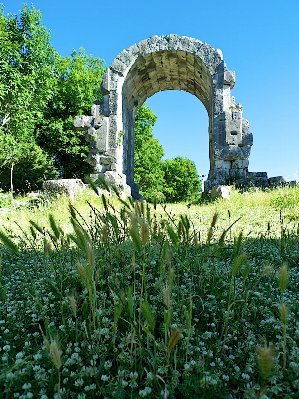
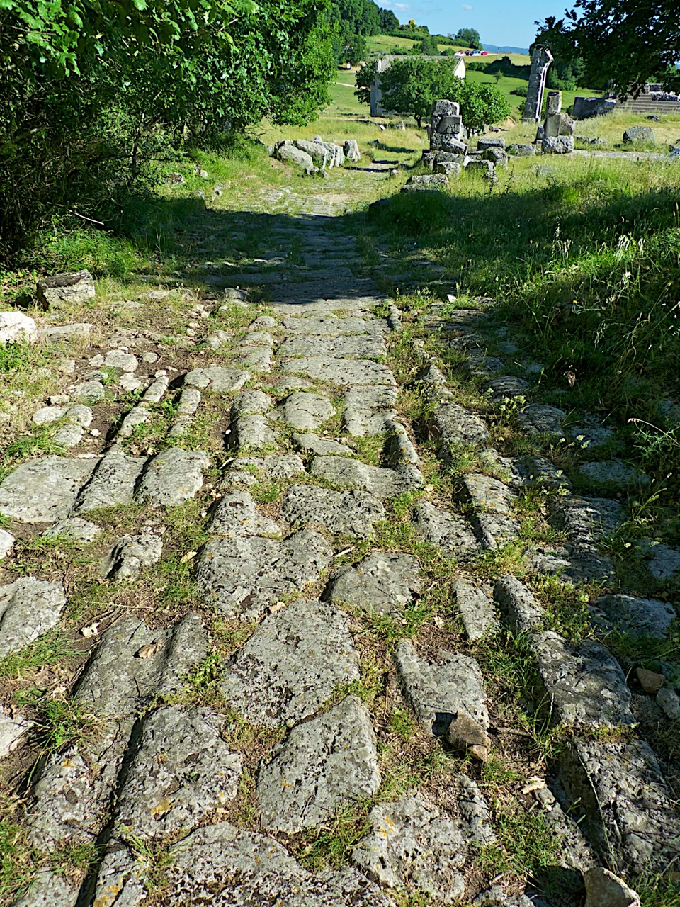
The ticketed area is a fenced expanse of meadow and trees of 22 hectares (it.wikipedia). The Via Flaminia crosses it from south to north as the main street, paved with limestone blocks and in places with its pavements and drains (Ministry of Culture). Along it are the forum with its twin temples and a Capitolium, a series of public buildings, a large house, the basilica, the baths, cisterns, the theatre and the amphitheatre, and, at the northern end, the Arco di San Damiano, the arch through which the road entered the town, with the tombs of the cemetery beyond it (Ministry of Culture). Most of the buildings stand only a little above their foundations, because the abandoned town served for centuries as a quarry (de.wikipedia). Standing higher are the arch, whose central passage survives, and two tombs restored and rebuilt in the excavations of 1951–1972 (it.wikipedia). A small church of Saints Cosmas and Damian, built largely from reused Roman material, stands beside the forum (it.wikipedia).
The visitor centre at the entrance, named after the excavator Umberto Ciotti, holds the ticket office, a bar and a small museum of finds from the 1951–1972 excavations, and information panels and a free app reached by QR code, with reconstructions, accompany the route (Ministry of Culture).
Is it worth the trip?
Yes, if you are in southern Umbria or driving the E45 between Terni and Perugia. This is a whole Roman town centre with nothing modern on top, set in open country under wooded hills, and the Via Flaminia is here not a line on a map but a paved street you walk along. Two honest caveats. Much of what you see is low walls and foundations rather than standing buildings, so it rewards an unhurried walk with the panels or the app more than a quick look. And it needs a car: no public transport is mapped near the site. Allow for Monday closing and, in winter, a 17.30 close.
Getting there
Carsulae lies about 4 km north of San Gemini (en.wikipedia), within the municipality of Terni (it.wikipedia). The operator’s directions: leave the E45 at the San Gemini Nord exit (from Rome, the A1 to Orte and then the Orte–Terni link road onto the E45), turn left towards Cesi, take the right fork for Cesi, and turn left following the signs for the area. The free car and coach park is about 300 m from the visitor centre, reached by a footpath and an underpass (the operator). Part of the site has paths for visitors with limited mobility, who drive straight to the visitor centre and park there; not every area is easy to reach (the operator).
It is open Tuesday to Sunday, 08.30 to 19.30 from 29 March to 25 October 2026 and 08.30 to 17.30 from 26 October 2026 to 27 March 2027; the ministry gives last tickets at 19.00 in summer. A ticket for the site and the visitor centre is €5; €4 for EU citizens aged 18 to 25, permanent state-school teachers, groups of 15 or more and pilgrims with credentials; €3 for residents of Terni and San Gemini. A €2.50 ticket, for EU citizens under 18 or over 65 and school groups, is listed as covering the visitor centre only. Entry is free for disabled visitors and their companions, and for everyone on the state museums’ free days such as the first Sunday of the month, and a €12 combined ticket adds the Cascata delle Marmore waterfalls (carsulae.info, read 21 October 2026 – check before travelling).
Visiting details
- Opening hours
- Tuesday to Sunday 08.30–19.30 from 29 March to 25 October 2026, and 08.30–17.30 from 26 October 2026 to 27 March 2027. Closed on Mondays.
- Tickets
- €5 for the site and the Umberto Ciotti visitor centre; €4 for EU citizens aged 18 to 25, permanent state-school teachers, groups of 15 or more and pilgrims with credentials; €3 for residents of Terni and San Gemini. A €2.50 ticket for the visitor centre alone applies to EU citizens under 18 or over 65 and school groups. Free for disabled visitors and their companions, and for everyone on the state museums' free days, such as the first Sunday of the month. A €12 combined ticket adds the Cascata delle Marmore.
- Parking
- Free car and coach park about 300 m from the visitor centre (the operator); a path and an underpass lead from it to the entrance. Disabled visitors drive straight to the visitor centre instead.
Before you go
- Closed on Mondays, and from 26 October to late March the site shuts at 17.30.
- No bus stop or railway station is mapped near the site; it needs a car.
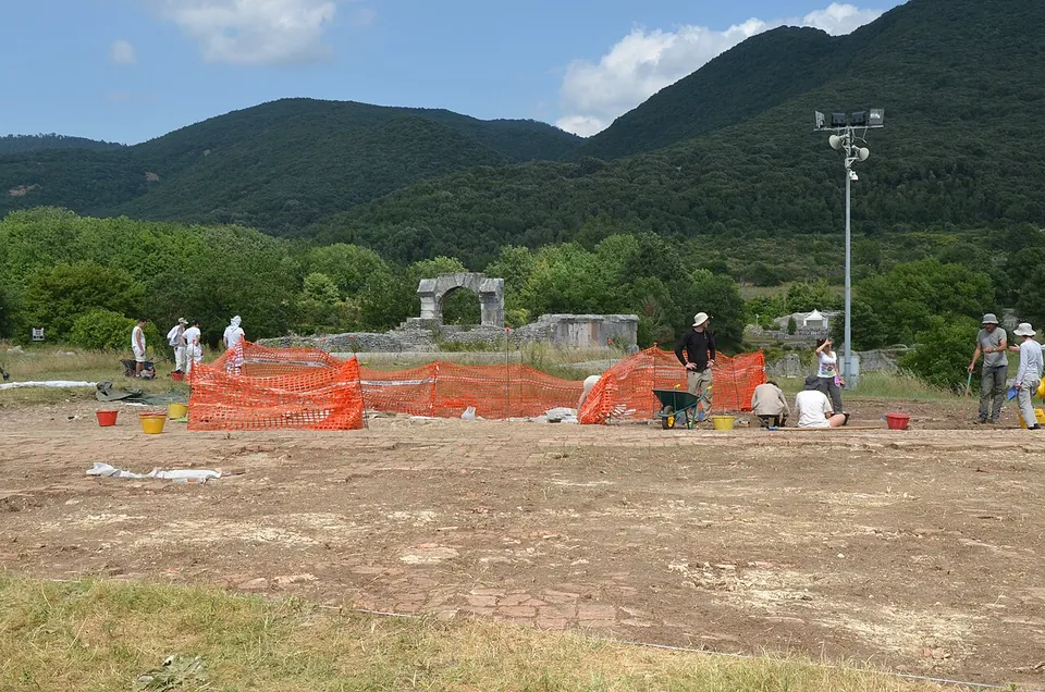
- The mosaic floors of the large house on the forum, found in recent excavations, have been covered again for their protection; a shelter that will put them on view is still being planned.
Hours and prices checked 21 October 2026 on the operator's own site. Confirm before travelling.
The forum, its temples and the basilica
The forum lies west of the Via Flaminia, on a platform carried on vaulted substructures built when the square was enlarged and regularised under Augustus (it.wikipedia). Its paving was of pink marble slabs, some of which are still in place, and two small four-way arches marked its entrances from the road; one has been partly rebuilt (de.wikipedia, it.wikipedia). At its south-east corner stand the podiums of two near-identical temples; to which gods they belonged is no longer clear (Pleiades), though their twin form has suggested Castor and Pollux (de.wikipedia). Opposite them are four rooms of different sizes, each with an apse, once lined with marble; nearby were found an over-life-size seated statue without its head and a portrait head of the emperor Claudius, and the largest room is thought to have been the town’s council chamber (de.wikipedia). On the west side a small temple, probably the Capitolium, was fully excavated in the campaigns that began in 2012 (it.wikipedia).
Across the road is the basilica, a three-aisled hall with an apse that served as a law court and place of business; only its two ends survive to floor level, and the rest is foundations (de.wikipedia). Facing the forum, excavations since 2017 have uncovered a large house of the end of the 1st century BC with reception rooms, peristyles, fountains and its own baths. Its black-and-white geometric mosaics are exceptionally well preserved, but they have been covered again to protect them. In February 2026 the Ministry of Culture announced over €2.3 million for a shelter that will put them on view and a complete refit of the visitor centre (Ministry of Culture).
The theatre and the amphitheatre
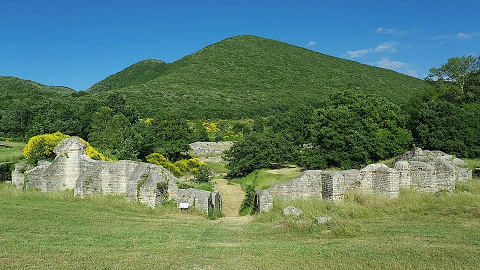
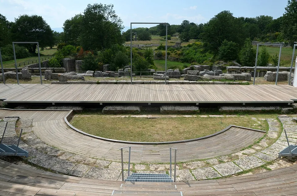
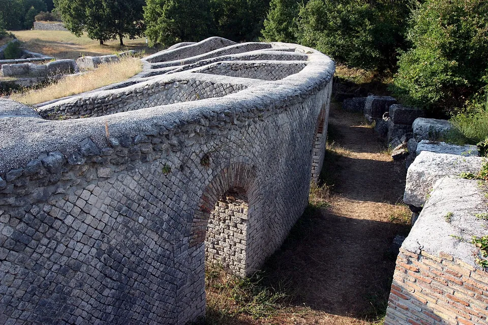
The two entertainment buildings lie side by side on the east of the town. The theatre was probably built under Augustus, before the amphitheatre, in net-patterned stonework (opus reticulatum) (it.wikipedia, Pleiades). Its semicircular seating, 62 m across, leans against the slope of the hill behind (de.wikipedia); today it carries modern timber seating and a stage. The amphitheatre was probably built under the Flavian emperors, of limestone blocks and brick (it.wikipedia). It sits in a hollow left by the collapse of the karst ground, which let the builders cut the lower rows of seats into its sides. Its oval measures about 86–87 m by 62 m (de.wikipedia, fr.wikipedia), large for so small a town, which suggests it drew spectators from the surrounding area (de.wikipedia). Near it, a stretch of the street from the Via Flaminia sank into another such collapse in antiquity: the subsided white paving was left where it fell and the road was patched with reddish limestone, a repair that can still be seen (de.wikipedia).
The Arco di San Damiano and the tombs
The Via Flaminia entered the town through a gate that probably had three passages, of which only the tall central one stands. It was built of squared limestone blocks that were meant to be faced with marble: the holes for the fixing clamps and the unfinished surfaces show where the cladding went (it.wikipedia). it.wikipedia dates it to the age of Augustus, while Pleiades describes it as an arch dedicated to Trajan, and it is also called the Arch of Trajan; its usual name comes from the church of San Damiano, since the two were the only buildings that stayed visible through the Middle Ages (it.wikipedia).
Beyond the arch lies the town’s only known and excavated cemetery. Its largest monument, nearest the arch, is a round drum on a square base, 17 m across, built of large blocks of local travertine and partly restored with its crenellated top. An inscription now in the Palazzo Cesi museum at Acquasparta, whose curve fits the drum, assigns it to the Furii family; no burials were found inside, so it is thought to have been a memorial to the family, with the graves in an enclosure beside it (it.wikipedia, de.wikipedia). Next to it a second tomb, a cylinder on a rectangular base under a Doric frieze, was rebuilt almost entirely by Ciotti from the stones found in excavation; of a third, only the base remains (it.wikipedia).
The baths
At the southern end of the town are the public baths, fed by natural springs (de.wikipedia). A series of rooms survives, the largest of them apsed, with furnace rooms and floors raised on pillars for underfloor heating (it.wikipedia). They have been excavated again by an American team since the 2000s (en.wikipedia, it.wikipedia).
History
The town owes its existence to the Via Flaminia, laid out from 221–220 BC by the censor Gaius Flaminius. Near Narni the road split into two branches; the western one ran through Carsulae as its main street, and people from the hill settlements around were drawn down to it; no archaeological traces at Carsulae itself are known from before the road (it.wikipedia). A wall of irregular dry-laid blocks near the baths is read by it.wikipedia as perhaps part of the road’s earliest phase, and by fr.wikipedia as pre-Roman. The town took shape under Augustus, when the forum was rebuilt with its public buildings and temples and the theatre, the amphitheatre, the basilica and the northern gate followed (it.wikipedia); de.wikipedia dates the building programme to probably soon after the restoration of the Via Flaminia in 27 BC. Strabo names Carsulae among the main places on the road, and Tacitus records that Vespasian’s commanders rested here for some days in AD 69, drawn by the wide view and the secure supplies (de.wikipedia). It was a self-governing municipium, and its inscriptions show building going on into the 3rd century AD (de.wikipedia).
Decline probably began in the 3rd century as traffic moved to the eastern branch of the road through Terni and Spoleto; no inscriptions are known from after Diocletian, and an earthquake probably damaged much of the town in the mid-4th century (de.wikipedia). Without walls, and on a branch of the road that had lost its importance, the town was gradually abandoned from the 5th or 6th century (it.wikipedia). It was then quarried by San Gemini, Acquasparta, Cesi and other places around (de.wikipedia). Federico Cesi took antiquities from it in the 16th century, Pope Pius VI excavated in 1783 and the archbishop of Spoleto in 1851. In 1950 the 22 hectares now fenced were expropriated, and from 1951 to 1972 Umberto Ciotti ran eighteen excavation campaigns that brought to light most of what is visible today (it.wikipedia). Work resumed in the 2000s and continues in the forum (it.wikipedia, Ministry of Culture).
More photographs



Nearby
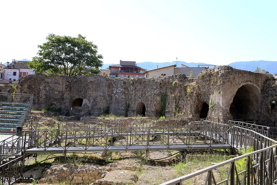
Photo: Sailko · CC BY-SA 4.0 · Commons
11 km · amphitheatre · Umbria
Anfiteatro Fausto
The oval is still easy to read on the ground, about 97.5 by 73 m overall (it.wikipedia).
Photo: ImagoAnimae · CC BY-SA 3.0 · Commons
Photo: JoJan · CC BY 3.0 · Commons


Straight-line distances.
Sources
Every fact on this page comes from the records below, each used under the licence noted.
| Source | Licence |
|---|---|
| Pleiades 413065 | CC BY |
| Wikidata Q519033 | CC0 |
| OpenStreetMap way/44394088 | ODbL |
| Carsulae — official site (orari e contatti) | licence not recorded |
| Carsulae — official site (biglietti) | licence not recorded |
| Ministero della Cultura — Area archeologica di Carsulae | licence not recorded |
| Ministero della Cultura — press release on the new mosaics at Carsulae (12 February 2026) | licence not recorded |
| Wikipedia (it) — Carsulae | CC BY-SA 4.0 |
| Wikipedia (de) — Carsulae | CC BY-SA 4.0 |
| Wikipedia (en) — Carsulae | CC BY-SA 4.0 |
| Wikipedia (fr) — Carsulae | CC BY-SA 4.0 |
| Pleiades — Arch of Trajan (Arco di San Damiano), Carsulae | licence not recorded |
| Pleiades — Forum of Carsulae | licence not recorded |
| Pleiades — Roman theatre, Carsulae | licence not recorded |
| Pleiades — Roman amphitheatre, Carsulae | licence not recorded |
| Pleiades — Roman baths, Carsulae | licence not recorded |
| Pleiades — So-called twin sanctuary, Carsulae | licence not recorded |
| Pleiades — Basilica of Carsulae | licence not recorded |