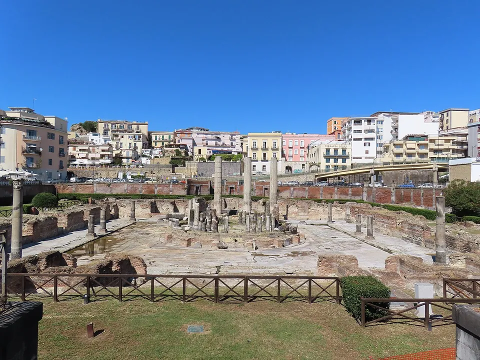
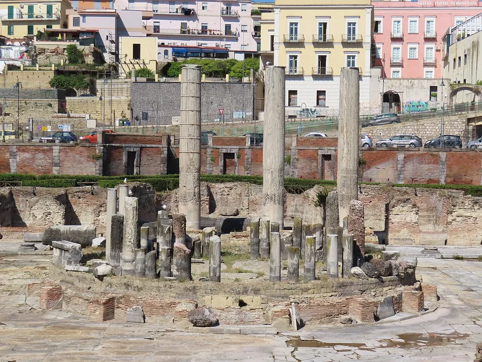
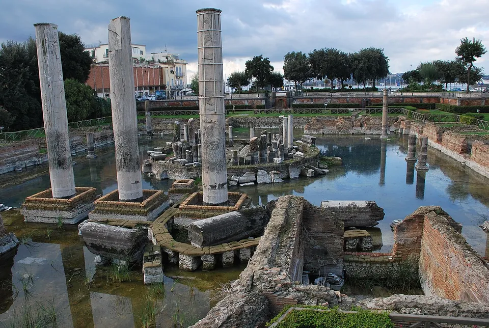


The Macellum of Pozzuoli was the food market of Roman Puteoli, long misnamed the “Temple of Serapis”. It matters as much to geology as to archaeology: its marble columns, bored by sea creatures, recorded the ground sinking under the sea and rising out of it again.
What is there today
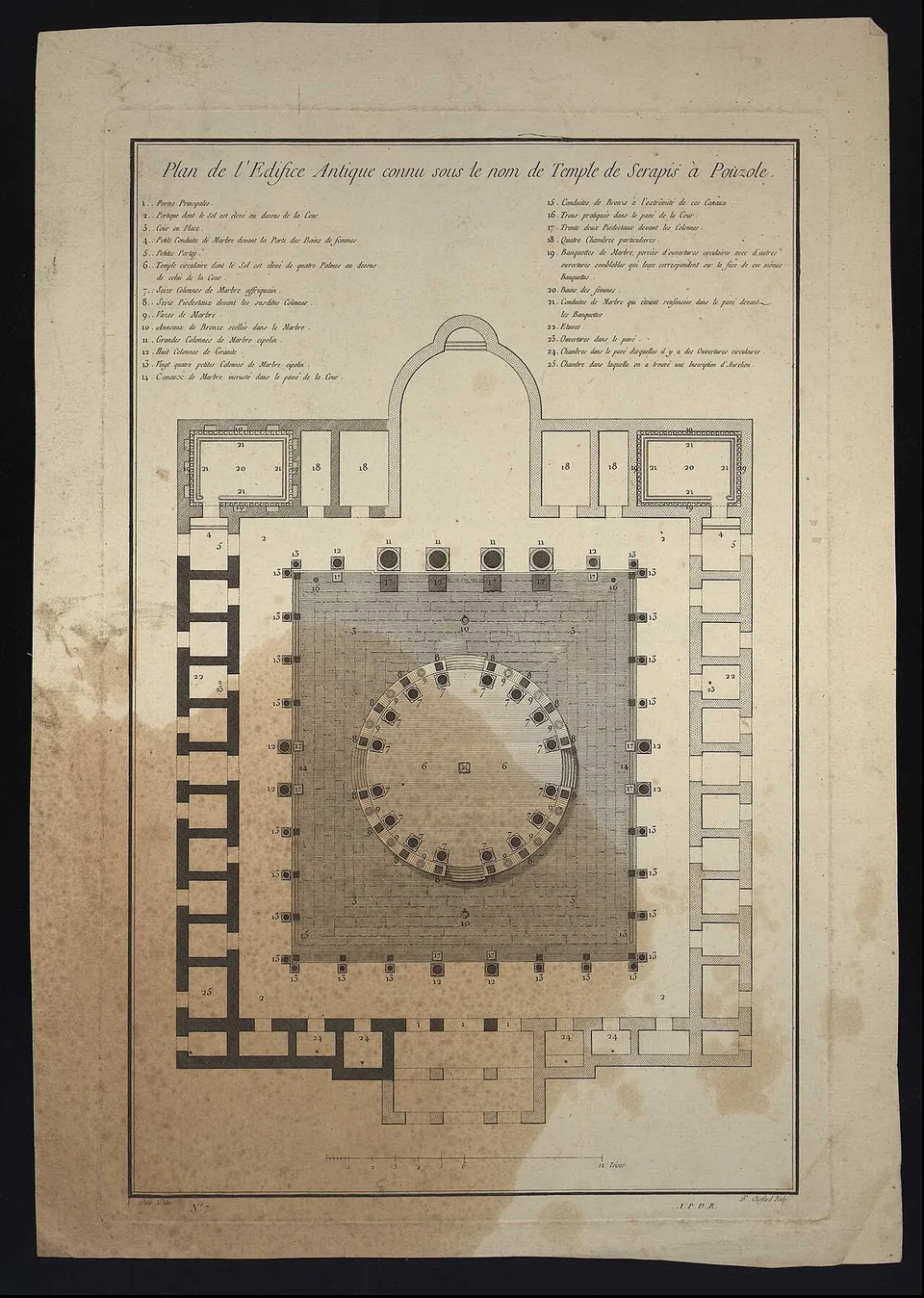
The whole plan of the market lies open in a sunken square of about 58 by 75 m, a few steps from the harbour quays in the centre of Pozzuoli (the operator). Its marble-paved courtyard is ringed by the brick walls of the shops. At its centre stands the podium of a round building, the tholos, about 18 m across, with the broken shafts of its columns still on it. Behind it rise the three tall columns that made the site famous: single blocks of cipollino marble that once framed the hall on the far side (the operator; en.wikipedia). Their lower half is pitted by the borings of a marine mollusc, Lithophaga, made while the building stood under the sea (en.wikipedia; the operator).
The site is temporarily closed to the public, and the operator gives no reopening date. The operator does not say whether the ruin can be seen from outside, but OpenStreetMap maps a viewpoint just outside the site’s edge and a history board beside it.
Is it worth the trip?
Not as a trip of its own while it is closed. It is in the middle of town, about 400 m from the Flavian Amphitheatre, so if you are in Pozzuoli for the amphitheatre or Rione Terra, walk past and see what the view from the edge gives you. If it reopens, it is worth a proper visit: Italian Wikipedia counts it among the grandest and most intact Roman markets, because the sea that covered it spared it the worst of the stripping. It has opened for one-off special events, such as an evening for the European Heritage Days in 2024 (Ministry of Culture), so check the park’s page before you go.
Getting there
The Macellum is at Via Serapide 13 in central Pozzuoli. The operator’s directions are the Cumana railway from Napoli Montesanto to Pozzuoli station, or by car the Naples ring road (Tangenziale) to the Pozzuoli/Arco Felice exit. OpenStreetMap maps bus stops on Via Sacchini about 70 m away and a paid car park about 120 m away.
No ticket is on sale while the site is closed. The 2024 special opening cost a symbolic €1, bought online only through Musei Italiani (Ministry of Culture). The operator lists the site as not accessible to visitors with reduced mobility (Parco Archeologico dei Campi Flegrei, read 24 October 2026; check before travelling).
Visiting details
- Opening hours
- Temporarily closed to the public. It has opened only for occasional special events, such as an evening opening on 28 September 2024 for the European Heritage Days, booked online in advance.
- Tickets
- No ticket is on sale while the site is closed. The 2024 special opening charged a symbolic €1, bought only online through Musei Italiani.
- Parking
- A paid surface car park about 120 m from the site (OSM way/613493122); bus stops on Via Sacchini about 70 m away.
Before you go
- The operator lists the site as not accessible to people with reduced mobility.
- The Campi Flegrei are an active volcanic area, and the park's sites close at short notice because of ground movement (bradyseism); check the operator's page before going.
Hours and prices checked 24 October 2026 on the operator's own site. Confirm before travelling.
The market
The market was built between the late first and early second century AD and restored under the Severan emperors in the third (en.wikipedia). The operator dates it to the late Flavian period from a partly preserved dedicatory inscription, and a lead water pipe inscribed with the name of Septimius Severus points to Severan rebuilding of the hall and the tholos. Recent study suggests the tholos itself was added in the third century (the operator).
The courtyard was surrounded by porticoes of grey granite columns, at least two storeys high on the long sides, with Corinthian capitals carved with shells holding dolphins (the operator). The shops opened alternately onto the courtyard and onto the outside: the inner ones were faced with coloured marble, the outer ones plastered and painted. The main entrance faced the sea and lined up across the tholos with an apsed hall on the far side, where three niches held statues for the imperial cult and the gods who protected the market (the operator; en.wikipedia). The tholos stood more than a metre above the courtyard floor on four stairways, surrounded by sixteen columns of pink African marble around an octagonal fountain (the operator). Two large latrines in the corners of the far side were finished so lavishly that the excavators first took the rooms for public baths (the operator).
Marine borings date the start of the building’s sinking to the end of the fourth century AD, the same time the market was abandoned. In the next century, partly buried, it became a small cemetery (the operator).
The “Temple of Serapis” and the birth of a geological idea
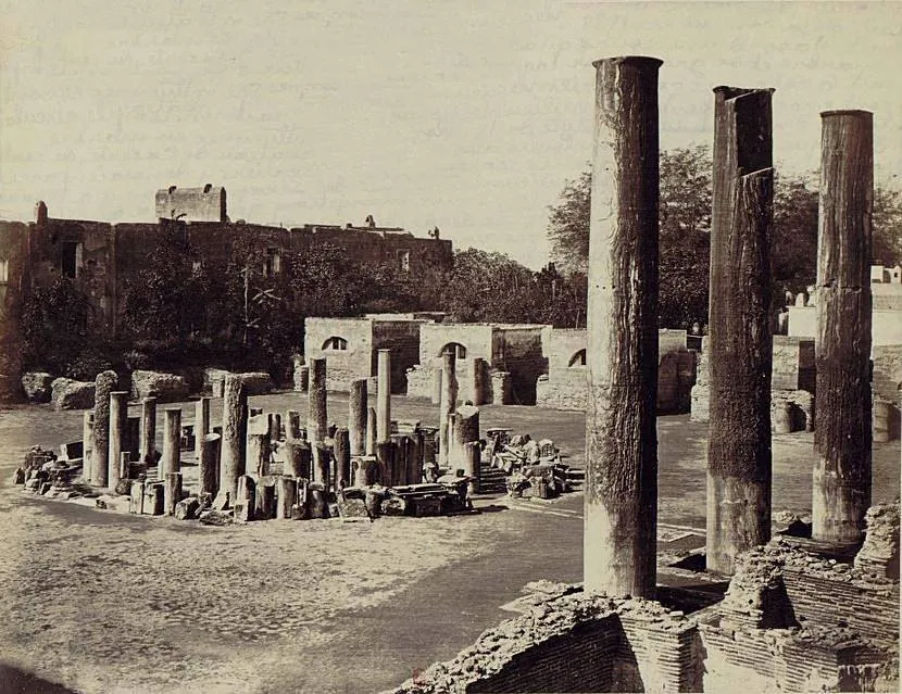
King Charles of Naples had the site dug between 1750 and 1756, after the tops of the great cipollino columns were seen poking out of a field known as the “vineyard of the three columns” (en.wikipedia; the operator). It lay under many metres of marine deposits (the operator). A statue of the Egyptian god Serapis turned up in 1750, so the building was taken for his temple (it.wikipedia). The statue is now in the National Archaeological Museum in Naples, with a plaster cast in the Campi Flegrei museum at Baia (the operator). The whole building was exposed between 1806 and 1818, and it was Charles Dubois, in 1907, who identified it as a market (en.wikipedia).
Long before that, the columns had become a puzzle for geologists. The band of mollusc borings showed that they had stood upright while the land sank below the sea and then rose again. Charles Babbage surveyed the ruin in 1828, and Charles Lyell put an illustration of the columns on the frontispiece of his Principles of Geology in 1830 to argue for slow, steady changes in the earth’s crust (en.wikipedia). The movement is now called bradyseism. The land rose about 1.7 m between 1969 and 1973 and almost 2 m between 1982 and 1994. Fears of an earthquake or an eruption led to the temporary evacuation of the city (en.wikipedia). That rise has left the building out of the water (fr.wikipedia), although water still stood over its floor in 2013, as a 2013 photograph on this page shows.
More photographs


Nearby
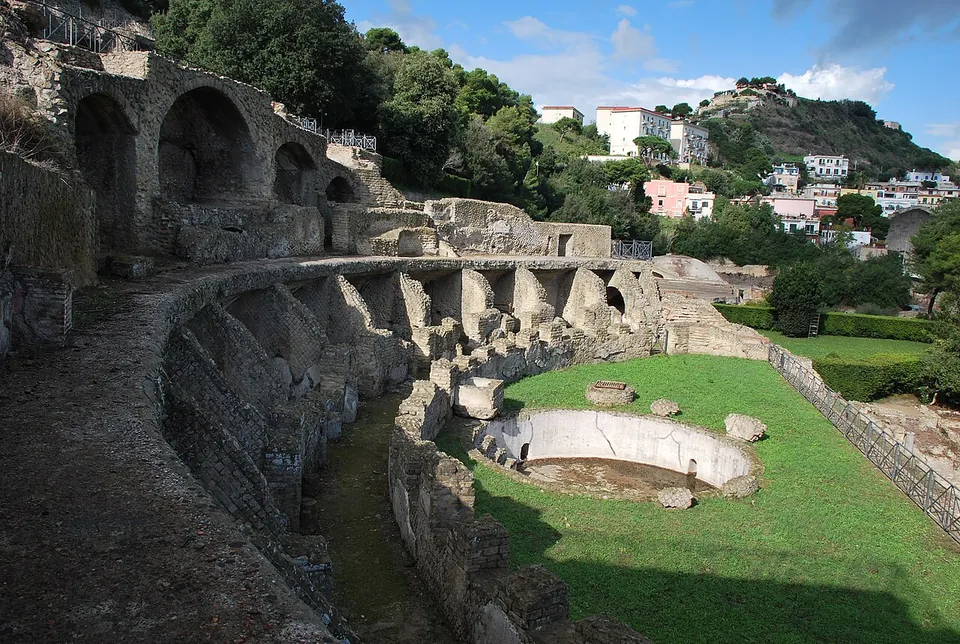
Photo: Lamberto Zannotti · CC BY-SA 3.0 · Commons
Photo: AM · CC BY-SA 2.5 · Commons
4 km · bath · Campania
Parco Archeologico delle Terme di Baia
The remains step down the slope in terraces along a front of about 450 m.
Photo: Vernetto at it.wikipedia · Public domain · Commons


Straight-line distances.
Sources
Every fact on this page comes from the records below, each used under the licence noted.
| Source | Licence |
|---|---|
| Pleiades 149888636 | CC BY |
| Wikidata Q954158 | CC0 |
| Vici.org 25183 | CC BY-SA (text), CC0 (metadata) |
| OpenStreetMap way/113738466 | ODbL |
| Wikipedia (en) — Macellum of Pozzuoli | CC BY-SA 4.0 |
| Wikipedia (it) — Macellum di Pozzuoli | CC BY-SA 4.0 |
| Wikipedia (fr) — Temple de Sérapis (Pouzzoles) | CC BY-SA 4.0 |
| Parco Archeologico dei Campi Flegrei — Macellum / Tempio di Serapide (the operator) | licence not recorded |
| Parco Archeologico dei Campi Flegrei — info, opening hours and closures (the operator) | licence not recorded |
| Ministero della cultura — European Heritage Days 2024, evening opening of the Macellum | licence not recorded |